Trail Walking Buenavista del Norte - 
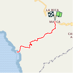
27 Barranco de Masca - Photo
 B0uille
B0uille

User

© OpenStreetMap contributors
Length
Length
8.2 km
Max alt
Max alt
614 m
Uphill gradient
Uphill gradient
863 m
Km-Effort
Km-Effort  
19.7 km
Min alt
Min alt
-6 m
Downhill gradient
Downhill gradient
863 m
Boucle
Boucle
Yes
Creation date :
2016-03-09 00:00:00.0
Updated on :
2016-03-09 00:00:00.0

(0 Reviews)

Walking
Walking
--
Difficulty : Medium

Scan this QR Code to open this trail in the SityTrail application

FREE GPS app for hiking

Logo SityTrail SityTrail

IGN / Geographical institutes

Download SityTrail from the App Store Download SityTrail from Google Play

Logo SityTrail SityTrail Plus

The world is yours!

Download SityTrail from the App Store Download SityTrail from Google Play Download SityTrail on Huawei AppGallery

About

Trail Walking of 8.2 km to be discovered at Canary Islands, Santa Cruz de Tenerife, Buenavista del Norte. This trail is proposed by B0uille.

Elevation profile

Points of interest

Point of interest Buenavista del Norte - Masca - Photo
B0uille
BUENAVISTA DEL NORTE 
Point of interest Buenavista del Norte - Puente - Photo
B0uille
BUENAVISTA DEL NORTE 
Point of interest Buenavista del Norte - Arco - Photo
B0uille
BUENAVISTA DEL NORTE 
Point of interest Buenavista del Norte - Cascada - Photo
B0uille
BUENAVISTA DEL NORTE 
Point of interest Buenavista del Norte - Playa de Masca - Photo
B0uille
BUENAVISTA DEL NORTE 

Positioning

Country:
Spain
Region :
Canary Islands
Department/Province :
Santa Cruz de Tenerife
Municipality :
Buenavista del Norte
Location:
Unknown
Start:(UTM)
319552 ; 3132448 (28R) N.


Close
My subscriptions